
Wednesday, June 30, 2010
Over the past 48 hours I have gone back and forth and have agonized where to go on vacation this year. One moment I want to stay close to home and just head up to Mammoth and Lake Tahoe but then the next moment I think about going back to Redwood National Park and the Oregon Coast which has been my favorite vacation spot for the past 17 years. I probably would have gone to Mammoth except that most of the trails I would like to hike are still covered in deep snow if you can believe that. We had an above average snow fall this year and one of the coolest springs I can ever remember and the high trails are not expected to open until the latter part of July.
What complicates matters on my end are a number of different things. One is the fact that I will be traveling alone. Because I am traveling alone I don’t want to go too deep into the wilderness because I have gotten quite lonely in the past just talking to myself sometimes for days on end. I also don’t want to go anywhere where I can’t get help if something happens. I broke my back in Redwood National Park while mountain biking by myself 12 years ago and that was one of the most traumatic events in my life. I was never in serious trouble but the thought of lying on a trail, like I was years ago, is something I want to avoid if possible. Another factor is my two sons who have chosen to stay behind. They are both 20 years and to be honest I get a bit anxious wondering what they might be doing at the house now that the old man if out and about. They have not been destructive before but I have never been gone for so long and let’s just say my imagination can get the best of me if I let it. Also, my mom’s health is not good at this time and I worry about her dying while I am off in the wilderness. I don’t carry a cell phone, because I don’t own one, and I know I would struggle with a lot of guilt if she died and I missed the funeral…which…is why I do intend to call every other day from a pay phone while I am gone.
So, after much contemplation and weighing a number of different considerations I have chosen to go to Colorado. Why Colorado? Earlier this spring I told myself I was going to break out of my old habit of going somewhere which is familiar and comfortable. For the past twenty five years I have traveled extensively in the Western United States and have exhausted the entire West Coast and every major mountain range west of the Mississippi River. I have been to the Canadian Rockies, Glacier, Mount Rainer, The Olympics, the Oregon Cascades, North Cascades National Park, The Sierras, Zion, Yosemite, and every other western National Park and major mountain range many times over. I have only been to Colorado once and that was when my children were very small. We didn’t camp, hike, or ride bikes. It was strictly a tourist trip where we stayed in various hotels and limited ourselves to all the major tourist attractions. I do remember enjoying the trip but we barely scratched the surface of this incredibly beautiful mountain wonderland.
Another reason I chose Colorado is because while I intend to be hiking and biking most of the time I will be staying in popular tourist spots like Aspen, Telluride, Denver, and Rocky National Park so there will be plenty of people around to chit chat with from time to time and if anything were to happen I feel secure knowing that there will be plenty of people around.
And finally, I am in the best shape of my adult life. I am currently checking in at 150 pounds and am in the best shape since my college days. I have lost 80 pounds since last summer and have worked my butt off by hiking, swimming, and mountain biking. You can’t imagine how hard I have worked at this and I feel like I need a payoff for all the hard work. Plus, since I have a history of chronic back problems this could be the last time I might be able to physically hike and bike some of the most rugged landscape in the U.S. So, the bottom line is that I feel like I need to take advantage of this open window before it no doubt closes in the years to come. I am 52 right now and I know I won’t be able to hike and bike some of the highest mountains much longer. So, there you have it.
I will be leaving on Sunday or Monday morning and driving to Flagstaff where I will camp and head out to hike the Grand Canyon the next day. The day after that I will be heading over to Mesa Verde National Park to check out the incredible cliff dwellings of the Anasazi Indians. From there I will be spending the next week in the mountain areas of Telluride, Aspen, and Rocky National Park before I head over to Denver and Boulder for some culture and city life. I’ll end my trip by either coming straight home or heading through Santa Fe New Mexico on my way home. I have heard so many wonderful things about Santa Fe and will try to fit it in if I can. During the trip I hope to take a lot of pictures and will post them on this blog either along the trip or when I get back. This will be a long trip and while I suspect I will get lonely at times I am excited to get the opportunity to see some of the greatest mountain scenery in the U.S.


Friday, June 25, 2010

“Hiking Steep Ravine Trail is like being baptized by the divine spirit of nature, and those who set foot on it will find a place where they can get their own brand of religion.” Tom Stienstra, author of California Hiking
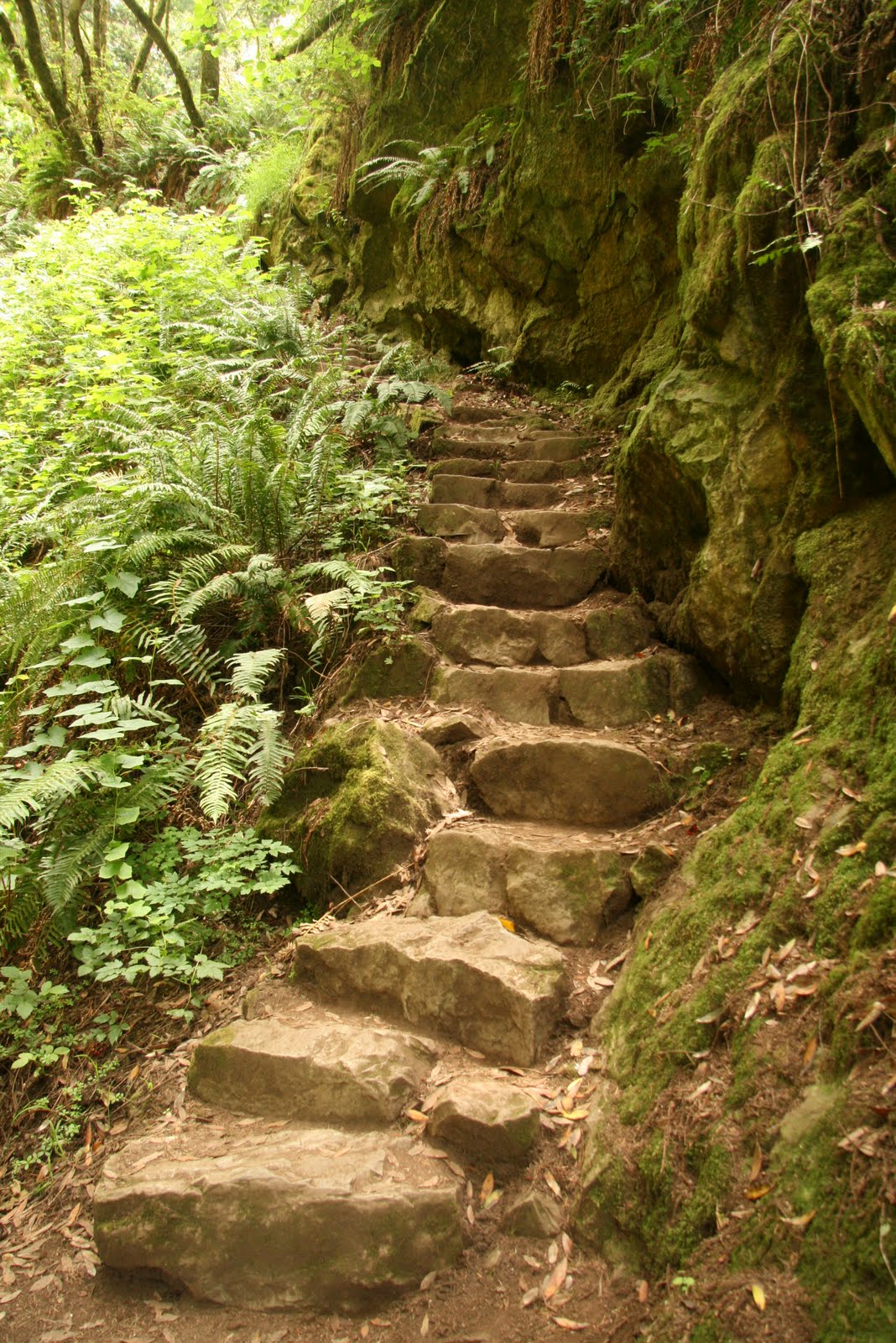
Today my son Wesley and I were “baptized by the divine spirit of nature” described by outdoor author and nature guru Tom Stienstra as we hiked the Steep Ravine Trail. The Steep Ravine Trail is located in Mount Tamalpais State Park which is located about 45 minutes from downtown San Francisco and is considered one of the great trails not only in the Bay Area but the West Coast. The Bay Area is an amazing place because it is surrounded by wilderness which include Redwood forests and canyons, incredible ocean and city lights vistas, rocky coastlines, and the largest elk herd in the state of California. It is a hikers and mountain bikers paradise just waiting and willing to reveal her hidden gems for those willing and able to explore her beauty.
Wesley and I spent the early afternoon hiking “up”, and I do mean “up”, the Steep Ravine trail. It is not the hardest trail I have ever hiked but the numerous boulder staircases encounters does make it a challenge, particularly, for those not in shape. Fortunately for me, all my hard work hiking up and down the bluff trails near my home three to four days a week made this hike relatively easy. I can’t speak for my son but I did notice him huffing and puffing quite a bit along the way. It should also be noted that the cool high 50 degree weather and the spectacular fauna, redwood forest, and “Amazon jungle like canopy conditions” does make the hike easier for those who are open to Mother Natures soothing massages. While I have never traveled to the jungles of South America this hike does have the feel that one is on the set of opening scenes of the first Raiders of the Ark movie for those fans old enough to remember. The Steep Ravine trail is my favorite Redwood forest hiking trail south of Eureka. I make this qualification because, imo, the best Redwood hikes, are located in or near Redwood National Park in the northwest corner of the state. If Redwoods and pristine ancient forests of the past are your cup of tea than you have to make the trek to this part of the state because that is where you will encounter one of the magnificent primeval forest of the world.
After hiking back down to our car from the top my son and I headed up to Mount Tamalpais. I have heard about Mount Tamalpais for years but have never actually been there for some reason. The hike to the top of “Mount Tam”, as the locals prefer to call it, is steep, but very short. I believe it is only a third of a mile, if that. The payoff for this short hike is the incredible, and I do mean incredible, view from the top. From the top you will have an uninterrupted 360 degree view of the entire Bay Area which includes the city, the bay, and the surrounding Santa Cruz mountains. I have included a few pics from the top but none of these pictures does the naked eye justice. It’s one of the great vistas I have ever seen, and that is coming from someone who has stood on top of various mountain passes in the sierras, the Grand Canyon, and numerous other vistas up and down the West Coast. On this particular day, late afternoon, the fog was beginning to creep up the rolling hills below and engulf everything in it’s sight, including the city and the bay. We couldn’t stay long at the top because we had one more stop to make before we headed back to San Jose but my brief stay at the top of the Bay Area world was more than well worth the time and effort to get there. I hope to get back up to Mount Tam again in the future because they say the sunsets up here are absolutely incredible. That trip will have to wait for another time so for now I will have to be content with knowing that “mother nature” still has more of herself to reveal to me when I have the time to indulge myself in her everlasting graces.
Thursday, June 24, 2010


Wednesday, June 23, 2010

Tuesday, June 22, 2010
Yosemite Valley is an "otherworldly" place. Each time I go there I literally feel like I am landed on and have entered another planet. There is no place like Yosemite. I am not suggesting Yosemite is better than all the other National Parks but Yosemite is absolutely stunning. It probably has something to do with waterfalls that cascade thousands of feet down the granite mountains that enclose the valley or standing face to face with El Captain which rises vertically over four thousand feet from the valley floor. Whatever it is, Yosemite Valley is an enchanting place.
My son Wesley and I spent the day riding our bikes through the valley floor in Yosemite. Riding a bike, imo, is the best way to see Yosemite because you don't have to hassle with parking and traffic congestion which seems to get worse with each passing year. There is an excellent bike path that traverses the entire valley floor. The bike path is paved and level, for the most part, and bike racks are conveniently located at all the major attractions. You do have to share the bike path with foot traffic which can get tricky because if you are not paying attention you might hit one of the other tourists and potentially ruin both of your day.
I have been to Yosemite Valley many times but yesterday was one of the best because of the incredible amount of water that is currently crashing out of the high mountain peaks which surround Yosemite National Park. Generally, the best time to see Yosemite is the first couple of weeks in June because that is when the falls, meadows, and wildflowers are all simultaneously peaking. The summer heat has also not arrived yet. Yosemite can get quite warm later in the summer so one might want to plan a trip earlier rather than later.
I wish we could have spent more time in Yosemite but we didn’t have reservations so we limited out stay to just one day before we headed off to our next adventure in the Santa Cruz mountains and one of my favorite places Point Reyes.

Monday, June 21, 2010


Wednesday, June 16, 2010

I recently spent three days camping and hiking in Sequoia and Kings Canyon National Parks. This was my first trip of the summer and I am “almost ecstatic” that my knees and back held up after hiking around 30 miles over a three day period. I have been training for this for a long time but one never knows how the body will actually hold up once you get out into the wilderness. It’s one thing to walk in the local foothills or a treadmill in a gym but it is quite another thing to be trekking up and down mountains that range between six and fourteen thousand feet which is what we have here in California.
Sequoia is the more popular of the two parks because of the magnificent giant sequoias and the fact that most of Kings Canyon National Park is wilderness and can only be accessed by foot. I spent the first day with my long time hiking buddy Seth hiking up to Mist Falls in Kings Canyon. The hike was about nine miles but not particularly steep in terms of Sierras standards. The falls gets it name from the fact that early in season the falls are roaring which creates a lot of mist as the water crashes against the large boulders which line the pathway of the river. Before we hit the trail we heard that the river was at a twenty year high due to the above average snow pack and the late spring runoff which is only now kicking into high gear.
The next couple of days I hiked four other trails and a saw a variety of sights which included beautiful meadows, a marmot, snow plants, giant lizards, numerous waterfalls, two bears, and lots and lots of giant sequoias. Although I have seen giant sequoias and coastal redwoods, many, many times over the years my eyes never get tired of these thousands of year old giants of the earth.
Last summer I was limited for the most part to walking on very short nature trails of less than a mile because I was hobbling around with a bad back and a cane. This summer, if my back cooperates and my schedule goes as plans, I hope to hike to some places I have not been able to access for over twenty years. And, Lord willing, I’ll bring back some pictures of some of the most incredible scenery on this side of heaven.


Subscribe to:
Comments (Atom)